|
Ningbo Paul Friction Material Co.,Ltd
|
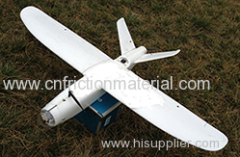
Fixed Wing UAS Autonomous Route IAS (FL-A1)
| Payment Terms: | T/T,L/C |
| Place of Origin: | Shaanxi, China (Mainland) |
|
|
|
| Add to My Favorites | |
| HiSupplier Escrow |
Product Detail
Hand throwing takeoff\ HD and real-time video downlink IAS within radius of flight of 10 Km(HD IAS within flight range of 60Km
Fixed Wing UAS Autonomous Route IAS (FL-A1)
Hand throwing takeoff, HD and real-time video downlink IAS within radius of flight of 10 Km(HD IAS within flight range of 60Km
Easy to Operate
8 minutes' preparing time, Auto flight with one button( including takeoff and land), Preset route or modifying route instantly
High Integration of UAS and IAS
More stable and reliable, easy to fly, without any debug
Portability
One 8kgs case(UAS,1.2mx0.4mx0.4m),
One 8kgs ground station(0.45mx0.35mx0.17m),Single man can carry them
Safer Flight
Strong foam structure; Highly reliable avionics, Power management, Protection when losing control, multi points data storage
Basic Equipment
Unmanned Aerial Vehicle System (UAS)
UAV and Carrying Case
Flight Controller
Ground Station(including antenna)
Motor and ESC
Propeller
Battery
Parachute
Rubber Band Catapult Assembly
UAV Information Acquisition System (IAS)
Pan-Tilt
Camera
Video Downlink
Signal Superposition System
Hand-held Image Display
Basic Parameter
Mission Radius:10km/30 km
Propulsion:Electric Motor
Flying Range:20km/60km
Size:1600mm(wing span)/1100mm
Endurance:60minutes
Maximum Payload Weight:1.5kgs
Cruise Velocity:54 km/h~72km/ (15m/s~20m/s)
Real-time Video Range:10km
Flight Altitude:100m - 1000m
Range of Data Link:50km
Net Weight:2.5kg
Hover/Position Precision(GPS mode):vertical: ± 0.5m, Horizontal: ± 1.0m
Flight Mode:Auto Route and RC(GPS)
Takeoff and Recovery:
Bungee with Rubber Band,
Parachute landing(recommend),
Hand Throwing,
Parachute Landing,
No Runway,only 100mx10m Place
Flight Environment:
Temperature:-25 degree~ +50 degree
Wind Resistance:Force 6 Wind(50km/h,13.8m/s)
Weather:Light Rain and Snow
Safety Precautions:
Low Voltage Protection(User Defined),Auto Return Flight
IAS(standard):
HD Camera(3 million pixel, 1080p video)
Dual Axis Pan-Tilt,Roll±45 Degree,Pitch0-90 Degree,Physical Damping System
Analog video downlink,flight data and image superposition system
Airborne data storage device
Ground Data Receiving Set


